7 best GPS navigators for the forest: for fishing, for hunting, for tourism
A hike or just outdoor recreation requires good orientation skills in unfamiliar terrain. Unfortunately, not everyone knows how to determine the direction by compass, sun or other signs. In order not to get lost, it is better to buy a navigator for the forest in advance. Even simple and cheap models do the job successfully, but more versatile models offer additional, often useful information. Only Garmin navigators are featured in this ranking, as experienced travelers say they are best for hiking.
TOP simple and cheap navigators for the forest
Even the simplest navigator for the forest without the Internet will help you quickly determine your location and get directions in unfamiliar terrain. The Garmin brand lineup includes several budget models, which are worth buying for those who use navigators infrequently, for example, for fishing:
Garmin Astro 320
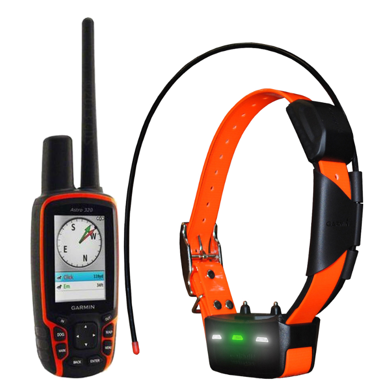
Inexpensive, convenient and functional navigator with built-in GLONASS support. The device has an integrated map, but the user can also upload their own. Information is displayed on the LCD-color screen. Orientation is carried out using a built-in antenna, you can also connect an external device using a special connector. The device operates on two AA batteries. They are enough for 20 hours of work. If the batteries run out, you can connect an external power source to the navigator. Additionally, the case provides a slot for Micro SD and USB-port, and in the memory of the device there is a hunting and fishing calendar, information about the sun, moon and tides, an alarm clock and an altimeter.
| Number of routes | 200 |
| Screen diagonal | 2.6 inch |
| The weight | 260 g |
Pros:
- 2 GB of internal memory;
- there is support for EGNOS and WAAS;
- integrated magnetic compass;
- USB cable included;
- convenient fastening clip.
Minuses:
- not very large radius of action;
- the case is not quite well protected from mechanical damage.
Review: “A normal navigator for my money. There are no unnecessary functions, everything you need is there, the controls are simple and straightforward. Recommend".
Garmin eTrex 10
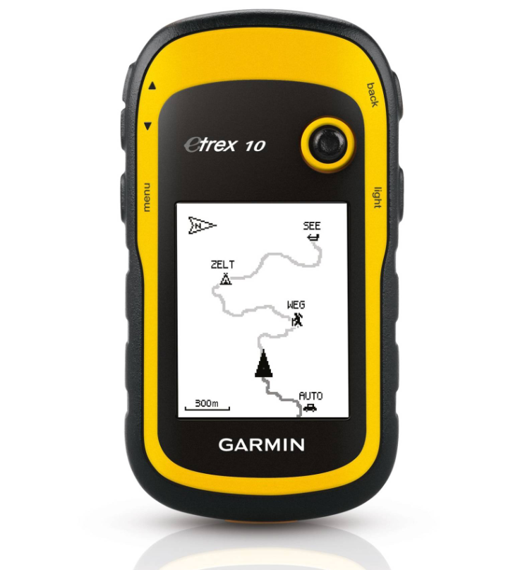
This GPS navigator for the forest, despite its affordable cost, successfully combines advanced functionality, long life and easy operation. The body of the device is protected from moisture and shock, so you can safely take the device with you on hikes. The built-in antenna is used for orientation, and the Track-Back function allows you to accurately plan a route even in unfamiliar terrain. Information is displayed on a small but informative LCD-monitor. The device also has a built-in card, there is an internal memory, but to increase its capacity, you can install an additional memory card using the Micro SD slot. If necessary, the device can be connected to a computer or laptop via USB, and the cable is provided in the kit.
| Number of routes | 50 |
| Screen diagonal | 2.2 inch |
| The weight | 142 g |
Pros:
- affordable cost;
- the case is protected from dust, dirt and moisture;
- a charge of two AA batteries lasts for 25 hours of use;
- quickly catches satellites and fixes deviations from the course;
- convenient menu and control.
Minuses:
- freezes for a few seconds when marking waypoints;
- not very large amount of built-in memory.
Feedback: “I have been using this navigator for a year, and I have bought products of this brand before. I can say this: while the device is new, it works well, but if the navigator breaks down, it is easier to throw it away. Repairs will be too expensive and not always possible. "
Garmin eTrex 20x
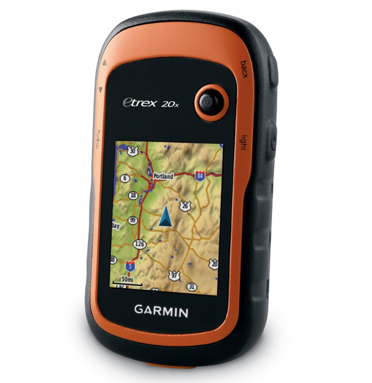
This high-quality tourist navigator for the forest will become an indispensable assistant for those who often relax in nature or go fishing and hunting in unfamiliar areas.The device is equipped with a color display, a built-in GLONASS-module and a waterproof case that reliably protects the internal filling from dust, dirt and water. The device is equipped with a route calculation function, a trip computer and the ability to independently download terrain maps. Communication with the satellite is carried out using a built-in antenna, and two AA batteries are used as a power source. This is enough to keep the device running smoothly for 25 hours. Also, the device can be connected to a computer via a USB port, and to expand the volume, a Micro SD memory card can be inserted into the device.
| Number of routes | 200 |
| Screen diagonal | 2.2 inch |
| The weight | 142 g |
Pros:
- there is a pre-installed road map of Russia;
- built-in memory 3.7 GB;
- there is a sound and vibration signal;
- reliable protection of the case from dust and moisture;
- simple and intuitive controls.
Minuses:
- not very large screen;
- the system slows down a lot when scrolling the map.
Review: “Inexpensive, but good navigator that really helps to navigate. It is especially pleasing that it holds the battery for more than a day, although the screen is small and you need to look very carefully at the small details on the map. "
Rating of good universal GPS navigators for the forest
The navigator, in order not to get lost in the forest, is considered one of the most important devices for hunting and tourism. If the issue of price does not play a key role, it is worth buying a Garmin universal device. These models are distinguished by advanced functionality and thoughtful management, so they are ideal for the forest:
Garmin GPSMAP 64st
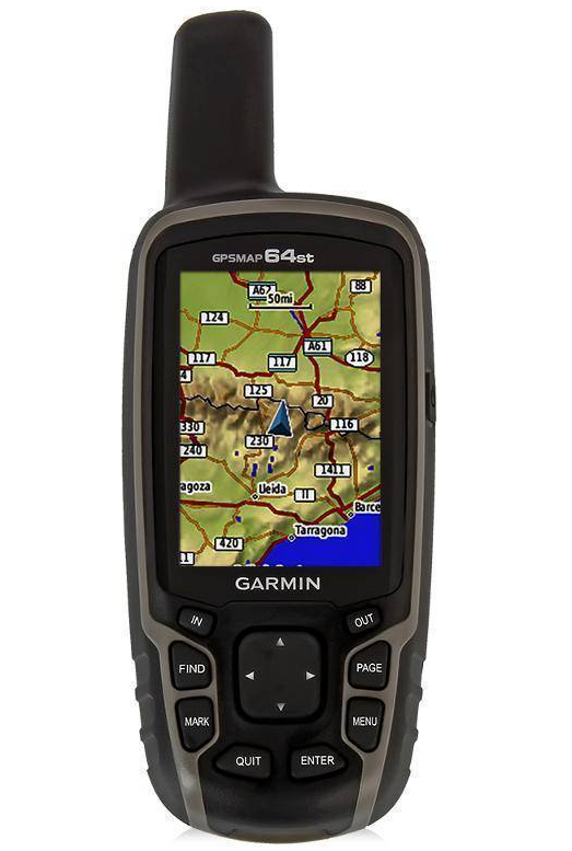
The compact and functional navigator with color screen makes it easy to navigate and allows you to plan a route in unfamiliar terrain. Inside the case there is a barometer, a magnetic compass, built-in maps of Russia and a route calculation function. All of these options make navigation easier. The device has a large amount of built-in memory (8 GB), but if this amount is not enough for the user, he can additionally insert a Micro SD card. As in other models of the brand, the device provides a connection to a PC via a USB port. The connection to the satellite is carried out using an external antenna. The device operates on a built-in battery, but in addition to it you can connect an external power source.
| Number of routes | 200 |
| Screen diagonal | 2.6 inch |
| The weight | 230 g |
Pros:
- waterproof shockproof case;
- quick search for satellites;
- you can charge the battery from the cigarette lighter in the car;
- stable connection to the satellite;
- convenient and simple push-button interface.
Minuses:
- not very high detail of the built-in maps, it is better to load them yourself;
- high price.
Review: “The navigator is quite good, although it may seem expensive to many. I like it because of its reliability, ease of use and advanced functionality. "
Garmin eTrex Touch 35

A compact, versatile navigator that fits easily into a jacket or backpack pocket. The information is displayed on a large touch screen, so the user does not have to strain his eyes to see the small details of the map. The body is made of shock and moisture resistant material. Due to this, you can be sure that the device will not fail at the most inopportune moment. Additionally, the device has a built-in electronic compass, barometric altimeter and pre-installed maps. If the user needs to download the plans of the area on his own, he can do it by connecting the navigator to a PC via a USB port.
| Number of routes | 200 |
| Screen diagonal | 2.6 inch |
| The weight | 159 g |
Pros:
- bright color display;
- compact dimensions;
- body resistant to moisture and mechanical damage;
- simple control and configuration;
- finds satellites quickly.
Minuses:
- the set does not include a carabiner for fastening;
- not very high quality screen resolution.
Review: “The device is simply indestructible. In addition to being a great help to navigate, it is also shock and moisture resistant.I have personally tested it more than once, and everything is fine. Recommend".
Garmin GPSMAP 66st
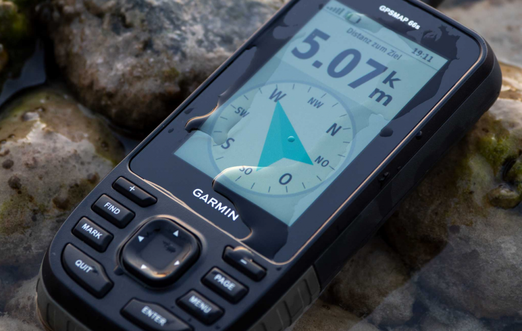
A compact universal navigator with 16 GB of built-in memory will help you successfully navigate in any conditions. The device supports Bluetooth, so it can be paired with a smartphone. The functionality of the device is extended, and includes self-loading of terrain maps, route calculation, sound alarms and Track-Back function. The information is displayed on a large color LCD-display. Communication with the satellite is via an external antenna. Additionally, the device can be used to view photos, and the built-in barometer and magnetic compass will facilitate navigation in unfamiliar terrain.
| Number of routes | 250 |
| Screen diagonal | 3 inch |
| The weight | 230 g |
Pros:
- preinstalled road map of Russia;
- 16 GB of internal memory;
- there is a built-in flashlight-beacon for giving an SOS signal;
- compact dimensions;
- the battery lasts 25 hours.
Minuses:
- high price;
- some users complain about the long loading of maps.
Review: “For me this is the best navigator for the forest. I always take it with me on the road. The cost is high, but it is justified by the extended functionality. "
Garmin GPSMAP 276Cx
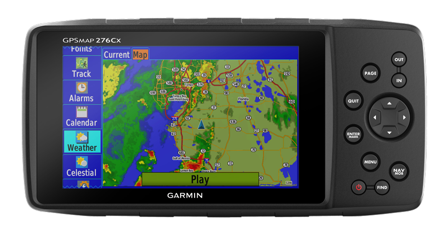
One of the most expensive navigators in the Garmin lineup, but its high price is fully justified by its thoughtful functionality. The device already has pre-installed maps, but, if desired, the user can download them himself. The internal memory of the device is 8 GB. This is sufficient for most users, but there is also an additional Micro SD slot in the case. The device supports a connection via Wi-Fi and Bluetooth for synchronization with a smartphone, and a USB port is provided for communication with a PC. The set includes special fasteners for secure fixation of the navigator, and its durable case is reliably protected from shock and moisture, so the user can not be afraid that the device will fail at the most inopportune moment.
| Number of routes | 250 |
| Screen diagonal | 5 inch |
| The weight | 450 g |
Pros:
- large screen diagonal;
- EGNOS and WAAS support;
- simple and convenient control;
- very bright screen with excellent detail;
- The housing is made of durable plastic that is resistant to shock and moisture.
Minuses:
- high price;
- large weight in comparison with analogues.
Testimonial: “An excellent orienteering device. But, like other navigators, it slows down slightly when loading pre-installed maps, so I recommend loading maps yourself. "
comparison table
Garmin navigators are rightfully considered the best for navigating unfamiliar terrain. The range of models is huge, and a comparative table of characteristics will help you choose the right device from the rating.
| Product name | Number of routes | Screen diagonal (inches) | Weight (in grams) |
| Garmin Astro 320 | 200 | 2,6 | 260 |
| Garmin eTrex 10 | 50 | 2,2 | 142 |
| Garmin eTrex 20x | 200 | 2,2 | 142 |
| Garmin GPSMAP 64st | 200 | 2,6 | 230 |
| Garmin eTrex Touch 35 | 200 | 2,6 | 159 |
| Garmin GPSMAP 66st | 250 | 3 | 230 |
| Garmin GPSMAP 276Cx | 250 | 5 | 450 |
Tips for choosing navigators for the forest
When choosing a navigator for a forest, first of all pay attention to the size of its display. It is advisable to choose a device with the maximum resolution, because the detail and comfort of viewing the map depend on this.
You also need to pay attention to the amount of built-in memory and the possibilities of its expansion. It is desirable that the device already have preinstalled maps, but the user should be able to download them independently by connecting the navigator to a PC or laptop.
Since the navigator is a device that is used in extreme conditions, its case must be durable, resistant to mechanical damage and moisture.
All these characteristics are fully consistent with the Garmin navigators described in the rating. If it is difficult to decide on the choice of a suitable model, it is better to choose a device with the maximum amount of built-in memory and the presence of additional functions.